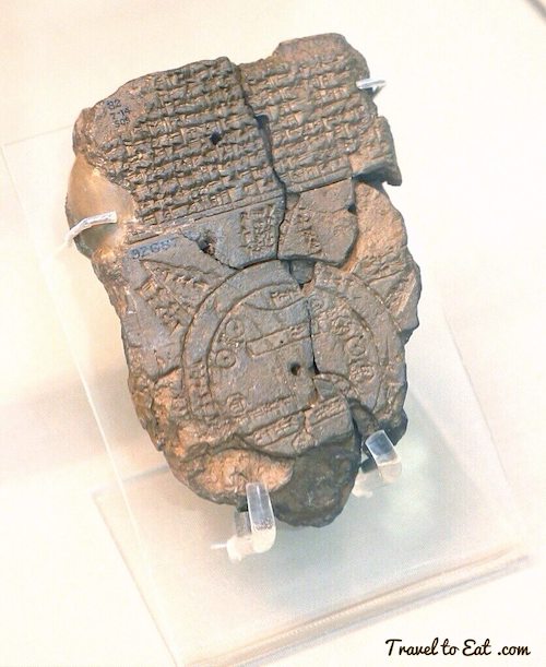
A damaged clay tablet discovered in the late 1800s in Sippar, Iraq is said to be the oldest map of the world. It was discovered on the banks of the Euphrates River, and published in 1899. Now housed at the British Museum, the damaged clay tablet dates back to 600 BC, and depicts an early interpretation of the layout of the world. At 122 x 82 mm, the small map gives us a glimpse into how the Babylonians viewed the world around them, both physically and spiritually.
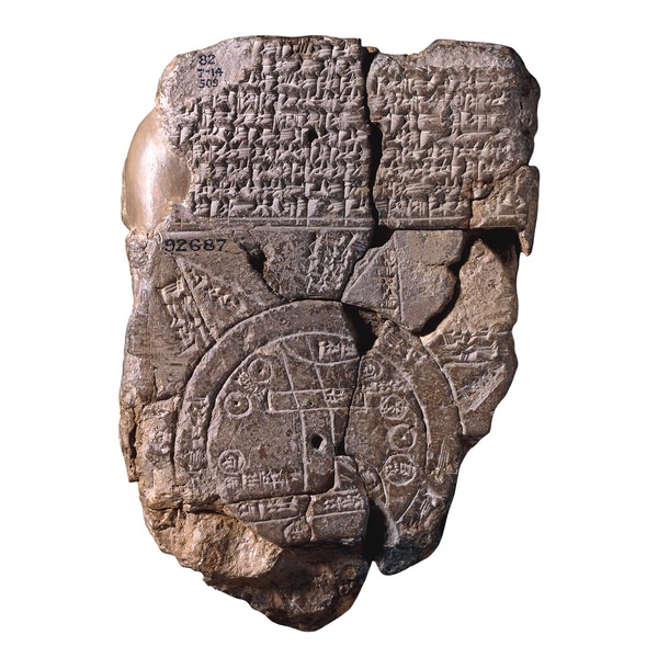
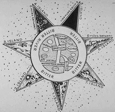
The tablet contains a map of the Mesopotamian world, with Babylon in the center. It contains carefully etched images and cuneiform writing. Babylon is surrounded by two concentric circles that represent the ocean, named “bitter water” or the “salt sea.” It is labeled with Babylon, Assyria, and Elam. Eight triangular areas labeled as “Regions” or “Islands” surround the Salt Sea, and are labeled with distances, descriptions of the regions, and descriptions of great heroes and mythical beasts that lived in each region. The southern marshes are indicated at the bottom of the map by two parallel lines, and a curved line near the top shows the Zagros Mountains. The Euphrates River is shown running from the mountains above, through Babylon, to the marshes below. Within the center of the map are seven labelled areas that appear to represent cities. Due to damage of the tablet, it appears that three islands are missing from the lower corner.
Three of the islands are labeled as:
- “place of the rising sun”
- “the sun is hidden and nothing can be seen”
- “beyond the flight of birds”
The below sketch shows a detailed outlined of the map and a key is provided showing the labels of each element.
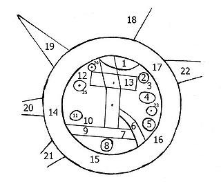
1.“Mountain” (Akkadian: šá-du-ú)
2. “City” (Akkadian: uru)
3. Urartu (Akkadian: ú-ra-áš-tu)
4. Assyria (Akkadian: kuraš+šurki)
5. Der (Akkadian: dēr)
6. Unknown
7. Swamp (Akkadian: ap-pa-ru)
8. Elam (Akkadian: šuša)
9. Canal (Akkadian: bit-qu)
10. Bit Yakin (Akkadian: bῑt-ia-᾿-ki-nu)
11. “City” (Akkadian: uru)
12. Habban (Akkadian: ha-ab-ban)
13. Babylon (Akkadian: tin.tirki), divided by Euphrates
14 – 17. Ocean (salt water, Akkadian: idmar-ra-tum)
18- 22. Mythological objects
It is believed that the map was intended to convey the entire contents of the world. It is unique in its inclusion of the islands beyond the ocean. All other maps produced during the same period were localized to the area in which they were created, did not include land beyond the ocean, because the ocean was considered the end of all lands.
The actual meaning behind the content of the map has been disputed. While many of the places are shown in their correct location, some have said that the map is intended to show the Babylonian view of the mythological world. The 18 mythological beasts mentioned in the writing on the map allude to the Babylonian Epic of Creation where the new world was created after the mythological animals were expelled to the “Heavenly Ocean.” Others say that the Babylonians engaged in cartography to assist in their exporting of agricultural surpluses. While the Babylonians were well-aware of other peoples, such as the Persians and Egyptians, the map creators specifically excluded those peoples from the map. The location of Babylon on the map shows that the Babylonians believed themselves to be the center of the world.
Artist’s depiction of the Babylonian Map of the World. Image source: Cartography-images
The discovery of artifacts such as the Babylonian Map of the World can answer many questions about ancient peoples, the way they lived, and the way they viewed the world, while also opening up new questions. What was their purpose in creating this map? Was it intended to be a literal interpretation of the geological world around them, or a representation of the mythological world they believed in? Questions such as these may never be answered.